The Geology Of Colorado Springs

On my Geology Field trip, I spent the day visiting four geologically interesting locations in the Greater Colorado Springs area, including Manitou Springs.

I visited Garden of the Gods, Seven Falls, Cave of the Winds, and the Florissant Fossil Beds National Monument. These were all locations that were tied in together, geologically, and yet each had something new and different to add to the geology and uniqueness of Colorado. It was almost as though each location built upon the next, like pieces of a puzzle that make a large picture when finished. As you read about each location, the puzzle pieces will begin to form a geological wonder.

This map below is of the geological features of the entire Colorado Springs and Manitou Springs area. Please use it for reference in the following report. (Please click on it to see the entire image and to zoom in.)


Works Cited Page


Location One: Garden of the Gods


City of Colorado Springs: Important Events in Garden of the Gods Geology. 01 June 2001. City
of Colorado Springs. 30 June 2007. http://www.springsgov.com/Page.asp?NavID=993.

City of Colorado Springs: Glossary of Garden of the Gods Geology. 01 June 2001. City of
Colorado Springs. 30 June 2007. http://www.springsgov.com/Page.asp?NavID=994.
Garden of the Gods and Vicinity, El Paso Co., Colorado, USA. 2007. Jolyon and Ida Ralph. 13

Location Two: Seven Falls


Seven Falls Night Lighting Expanded This Year. 2007. Hispania News. 30 June 2007.

Granite- About.com 2007. The New York Times Company. 13 July 2007

Igneous Rocks. 18 September 1997. Steven Dutch. 13 July 2007

Location Three: Cave of the Winds


Cave of the Winds, Manitou District, El Paso Co., Colorado, USA. 2007. Jolyon and Ida Ralph.
13 July 2007 http://www.mindat.org/loc.php?loc=133211&ob=4.

Timing of Passage Development and Sedimentation at Cave of the Winds, Manitou Springs,
Colorado, USA. 2007. Fred G. Luiszer. 7 July 2007
http://carsologica.zrc-sazu.si/downloads/361/luiszer16.pdf.

Cave of the Winds. 21 April 2001. Beth Gibson. 7 July 2007
http://members.aol.com/Gibson0817/cocave.htm.

Colorado Springs Natural Attraction: Cave of the Winds. 2007. Cave of the Winds. 7 July 2007
http://www.caveofthewinds.com/PikesPeakRegion.aspx.

Energy Institute: Education Glossary. 2007. Energy Institute. 7 July 2007
http://www.energyinst.org.uk/education/glossary.


Location Four: Florissant Fossil Beds National Monument


Florissant Fossil Beds National Monument. 25 July 2006. National Park Service. 12 July 2007 http://www.nps.gov/flfo/siteindex.htm.

Florissant Fossil Beds National Monument Plot Data. 03 July 2007. US Geological Survey.
12 July 2007 http://biology.usgs.gov/npsveg/flfo/images/flfoplots.jpg.

Geology Fieldnotes: Florissant Fossil Beds National Monument Colorado. 01 April 2005.
National Park Service. 12 July 2007 http://www2.nature.nps.gov/geology/parks/flfo/.

Stratigraphy of the Upper Eocene Florissant Formation, Colorado. 07 November 2004. The
Geological Society of America (GSA). 12 July 2007
http://gsa.confex.com/gsa/2004AM/finalprogram/abstract_75057.htm.

An Inventory of Paleontological Resources From the National Parks and Monuments in
Colorado. 2000. Rebecca Scott, Vincent Santucci, and Tim Connors. 13 July 2007
http://www2.nature.nps.gov/geology/paleontology/pub/fossil_conference_6/scott.htm.

Department of Mineral Resources Geological Survey. 26 September 2006. North Dakota State Government. 13 July 2007 https://www.dmr.nd.gov/ndfossil/poster/brule/brulep5.asp.


General Resources:

Dictionary.com. 2007. Lexico Publishing Group, LLC. 12 July 2007 http://dictionary.reference.com/.

Mapquest.com. 2007. Mapquest, Inc. 20 June 2007 http://www.mapquest.com/.

Location Four: Florissant Fossil Beds National Monument, Florissant, Colorado


The Florissant Fossil Beds National Monument is considered to be one of the most abundant and diversified fossil sources in the world. The fossils contained in Florissant have been studied and catalogued for over 130 years. Florissant Fossil Beds National Monument and the practices applied there have revolutionized paleontology for the rest of the world, helping to give people a better understanding of paleoclimate (climate from a former geologic period), paleoecology (ancient plants and animals and their environment), paleobiogeography (the study of the geographic distribution of fossil organisms), evolution, and taphonomy (the conditions and procedures of fossilization).
Over 1700 species have been described from Florissant, including the remains of various plants, insects, fish, and some animals. Some of the more interesting fossils recovered was the remains of a Brontothere, which is a rhinoceros-type animal from the dinosaur period; a Mesohippus, which is an ancient horse ancestor; and Oreodonts, which were pig-like animals that are now completely extinct.

Mesohippus, https://www.dmr.nd.gov/ndfossil/poster/brule/brulep5.asp


The history of Florissant Fossil Beds National Monument ties in, of course, with the history of the rest of the sites we have talked about. Towards the end of the Precambrian period (the Proterozoic period), between 500 and 600 million years ago, the Pikes Peak Granite Formation was formed. Probably 36 million years ago or slightly before then, the Florissant Formation was deposited into an upland paleovalley (an ancient valley) in the Pikes Peak Granite and the upper part of the Eocene Wall Mountain Tuff, which is dated to be 36.7 million years old.

Approximately 35 million years ago, the area was a large lake, about 15 miles long. The climate was warm, and humid, and the environment was plush, with a plentiful supply of ferns, and a large mixture of trees, including the very large Redwood trees. The plant and animal life is very abundant. There is also a large supply of insects to feed off of the swamp-like ecosystem.
There are active volcanoes, and for around 700,000 years, the volcanoes erupt violently. The eruptions cover the surrounding mountainside in ash, pumice, tuff, and dust. Animals, marine life, and insects get caught in the volcanic gasses and particles and dying, fall into the lake to be buried at the bottom. As time goes on, layers upon layers of fossils begin to accrue, and the lake begins to diminish. The lake dries up and becomes layers of shale. The trees burn up and get petrified. The entire ecosystem changes.
The Florissant Formation is composed of several different types of rock. This is mostly a result of the volcanic eruptions overlying the lake habitat. The formation is layered, with its fossil-rich layers consisting of tuffaceous mudstone and siltstone, shale, arkosic and volcaniclastic sandstone and conglomerate, and tuff. The way the layers are deposited and the types of deposition lead scientists to believe that there was two occurrences of lacustrine events (pertaining to lakes, absence of vegetation and trees), two occurrences of fluvial deposition (pertaining to or produced by a river) and one occurrence of lahar deposition (deposit left by a volcanic landslide). The fossils of the Messohippus and Brontothere are from the fluvial deposition parts of the Formation.

Florissant Fossil Beds, http://biology.usgs.gov/npsveg/flfo/images/flfoplots.pdf

There is still a plentiful supply of fossils at Florissant Fossil Beds National Monument, and much is still waiting to be explored and discovered. You can walk through the park to see the hills of shale and tuff, the petrified redwood and other trees, abundant plant life, and inside the information center they have many fossils displayed for people to see. You can take guided tours throughout the park to learn about its history and the various fossils. It is both a unique and a wonderful place to explore.

Location Three: Cave of the Winds, Manitou Springs, Colorado


The Cave of the Winds was formed in an interesting way. Over 1.8 billion years ago, the Rocky Mountain area was once covered by ocean, with shellfish living in the ocean, which typically dropped to the sea floor and began decomposing. Sediments grew up to approximately 40,000 feet high. As they did this, the sediment concreted and compressed into sedimentary rock. During a period of progeny, it became the Idaho Springs Formation.


500-600 million years ago, the Pikes Peak granite and Idaho Springs metamorphic occurred, and the sea began transgressing. About 425 million years ago, the Manitou Formation was formed, where the Cave of the Winds is located. The sea got deeper again, retreated, and repeated this pattern until around 135 million years ago, when it became a swamp land and shellfish became limestone, and compressed. As the ocean retreated, the limestone was exposed.


The Laramide Orogeny, which began approximately 75 million years ago in the Late Cretaceous period, then caused the uplift of the Rocky Mountain region. This resulted in the Ute Pass and Rampart Range Faults becoming active, which caused folding, faulting and jointing of rock. This allowed water mixed with carbon dioxide to flow through the rock, dissolving the limestone.


When the water table finally fell below the level of the caves, which resulted in the cave system being filled with air. As the remaining carbonic acid (water mixed with carbon dioxide) dripped through the folds, faults and joints in the cave system’s ceiling, it formed the stalactites and stalagmites and other formations that you can see when you walk through the caves. That is what formed what we now call Cave of the Winds and the surrounding caves. Additional uplift created the erosion of overlying sediment, which helps scientists to age the different caves and passageways.

Cave Map, http://carsologica.zrc-sazu.si/downloads/361/luiszer16.pdf


Cave of the Winds is a cave system suspected to be at least 70 million years old. There is an alluvial terrace sitting above the caves, which can be used to help date the youngest stream deposits in the caves. Scientists are currently in the process of dating this alluvial terrace. The fact that the Cave of the Winds is caused by erosion makes it very difficult, if not impossible, to determine its exact age. However, there are certain clues that help determine the ages of certain areas of the caving system. Some of the paleo-caves and paleo-sinkholes are filled with sediment that dates back to the Devonian to Late Mississippian periods, and the initial cave contain sediment rich in shale beds from the Pennsylvanian and Late Cretaceous periods.

Hydromagnesite,

http://www.mindat.org/loc.php?loc=133211&ob=4


Some important minerals are found in the Cave of the Winds. Aragonite is a polymorph of natural calcium carbonate formed from low-temperature and pressure aqueous solutions. Calcite forms as a chemical sedimentary deposit, such as limestone, and can be regionally or contact metamorphosed into marble. Hydromagnesite is a hydrated magnesium carbonate, formed in cool, hydrothermal areas.


Most of the walls of the cave are gray and tan, although in some areas, like the Mysterious Temple of Silence, there are red, green, blue, and yellow colored lights, casting an eerie feel to the room. There are several small channels reaching up to the outside, and you can see where the old passageways used to be. Some of the stalactites and stalagmites are greasy from being touched and you can see where people have tossed coins and hair clips for good luck. It is almost sad what humans do to nature, and at the same time, humans are nature.


The Cave of the Winds is as interesting geologically as it is beautiful to look at and discover. As you walk through the various caves, you learn so much about geology, caves, history, and even mankind as you see the old rope ladders and the natural formations. It is a sight to explore in length, as there are a couple different guided tours you can take throughout its passageways.

Location Two: Seven Falls, Colorado Springs, Colorado


Seven Falls is a waterfall, breaking in seven points along its descent, falling down from a sheer granite mountainside. It is breath taking to look at, particularly at night, where men have placed colored lights alongside it to light the waterfall up with remarkable colors that change every few seconds. There are countless steps that take you to the top of the granite waterfall, or an elevator leading to a platform half-way up so that you can enjoy the beauty of the waterfall and surrounding mountainside. But the geology of Seven Falls makes it more marvelous than even the average person would suspect.


The Seven Falls is located in the South Cheyenne Canon, which consists of Pike’s Peak Granite. This formation of granite dates back to approximately one billion years ago. This is when a large batholith rose upward from deep within Earth. Made up of igneous rock, this is the same granite found in Pike’s Peak, hence the name of the formation. Pike’s Peak Granite is produced from a combination of mica, quartz, and pink feldspar. As the ancient Rocky Mountain area began to erode, it eventually became a flat terrain known as a peneplane. 500-600 years ago, the batholith was exposed, and is now revealing an area of several hundred square miles.


Over the past several decades, the melting snow, rain and other water from the Pike’s Peak mountains have rushed down over the South Cheyenne Canon, eroding and carving a path into the canon to form Seven Falls. It is about 181 feet from the top of the granite cliff of Seven Falls to the bottom. The highest granite cliff in the South Cheyenne Canon, however, is 980 feet from its top to the canon floor. Granite is the most abundant and important mineral in the South Cheyenne Canon and the Seven Falls area.
As you explore Seven Falls, take the time to walk up the multitude of steps to the highest platform, and look from the top of the waterfall downward. It is an awe-inspiring sight to see, perhaps not one for the faint, and will increase your appreciation for its geological formation. It is especially beautiful at night, when it is lit up with the lights. There is an elevator taking you half-way up, for the easy-going, but I recommend the stairs to anyone who wishes for a truly humbling experience. Seven Falls is a marvelous sight.

Location One: Garden of the Gods, Colorado Springs, Colorado


I started my road trip with a nearly hour-long drive along Highway I-25 which ended up at the Garden of the Gods in Colorado Springs. The Garden of the Gods is a stunning creation of various stunningly colored rocks, formed mostly of clastic and chemically precipitated sedimentary rocks, deposited in layers.


The Garden of the Gods includes several different types of rocks. These rocks are tilted upward, which was a result of Laramide Orogeny, which means that they were uplifted during the mountain building of the Laramide period, approximately 70 million years ago. The Laramide period occurred during the Cretaceous period, just after the extinction of the dinosaurs. During the period from 60-70 million years ago, throughout the Paleocene age, the rock layers were tilted upright while still low underground. As the mountains rose, erosion removed most of the softer layers, exposing the layers of rock that form the Garden of the Gods that we see today. It is speculated that there is still some uplift occurring even today.


The amount of stress in the strata, or layers, of rock during the Laramide period caused many faults to occur within the Garden of the Gods. The faulting is the reason that these layers are so vertical, and can often be moved diagonally or laterally and may seem out of order. The Rampart Range Fault is the main fault that caused the Garden of the Gods to be vertical and overturned. It actually starts in the Garden of the Gods and runs north for about 30 miles. The arid climate also helped to create the type of erosion, and the Garden of the Gods was a product of differential erosion, meaning that the shales and mudstones eroded more easily in the wind, water, and ice exposure than the sandstone.


We started our hike walking around the park from the east to the west, and the layers of the rock get older as we went along. As we travelled around the park, the layers of rock we saw, in order of youngest to oldest are:


The Pierre Shale is a clastic rock formation found in the Garden of the Gods. These rocks consist mainly of mud. This is the thickest and most common formation in Colorado Springs, and also contains fossils, although these fossils consist mainly of clams, fish, and ammonites. This is the newest layer, and is thought to have originated from the Paleocene period, between 60 and 70 million years ago.
The Niobrara Formation is a limestone formation, which is a chemically precipitated rock, although fine-grained and overflowing with marine fossils. The fossils found in the Niobrara Formation include shark teeth. This formation was formed from a deep-sea environment. This formation is thought to have formed between 70 and 135 million years ago, during the Cretaceous period.


The Benton Group Formation is made up of shale and limestone, and is also clastic, resulting in the sea becoming more shallow and flowing over the beach. The softer shales are easily eroded. This formation was also formed during the Cretaceous period, between 70 and 135 million years ago.


The Dakota Sandstone Formation is another clastic sandstone in nude, gray, and yellow colors, layered with shales. It was formed from a marine environment that settled on or near a beach. This formation is part of the Dakota Group. This is another formation formed during the Cretaceous period.


The Purgatoire Formation, also part of the Dakota Group, is made up of clastic shales, siltstone, and whiter shades of sandstone. There is only a small hill directly behind the Ute Indian Trail marker that consists of this formation, and it is believed that it came from a flood plain environment. This formation also comes from the Cretaceous period.


Morrison shales and clays, wh
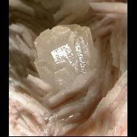
ich accumulated in a warm, damp, lowland environment are one of the layers of rocks found in the Garden of the Gods. This is more commonly known as gypsum, and is thought to have formed from a slow-moving river. The small white hills on the Ridge Trail come from this formation. (The Morrison Formation is also known to hold dinosaur fossils in other areas of Colorado, such as Morrison, which is also how the formation got its name.) The lower layer of gypsum is chemically precipicated, whereas the rest of this formation is clastic (the shales and clays). This formation was deposited approximately 150 million years ago, during the Jurassic period.


The Lykins Formation is a reddish colored layer of chemically precipitated rock, thinly bedded and made up mostly of shales and siltstones, such as dolostone and limestone. These layers are created in a marine environment, and are fossil algae called Stromatolites. The Lykins Formation is thought to have formed between 225 and 270 million years ago, in the Permian period.


The next layer of rock is the Lyons Sandstone formation. This formation is also made up of clastic rock, particularly cross-bedded, fine grained quartz sandstone. It is believed that the Lyons Sandstone formation is a solidified sand dune. This formation was also formed between 225 and 270 million years ago, during the Permian period.


Gradually changing from the Lyons Sanstone formation, you can see the next rock layer formed there, which is the Fountain Arkose Formation. This is a very coarse grained formation and consists of over 25% feldspar, also containing large quartz crystals. It is a formation of rock that is extremely old, and shows the history of ancient Rocky Mountains. It is believed that this formation was deposited approximately 275-310 million years ago, during the Pennsylvania period. This layer of clastic rock comes from stream deposits.


Stronium

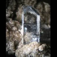
Some important minerals found in the Garden of the Gods are Celestine, the most common strontium mineral, and gypsum, which is formed from arid marine environments.
The Garden of the Gods is a beautiful park filled with various layers of rock, which to the untrained eye is simply a wonder, but to the geologist who knows or learns it’s amazing history, is incredible.


Celestine
http://www.mindat.org/loc-6113.html
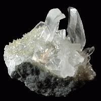


Gypsum


There were so many wonderful sights to see, with the rocks forming so many interesting shapes, such as the “Kissing Camels”, “Siamese Twins,” and the “Praying Hands” that it was hard to select just a few pictures to share the beauty of the Garden of the Gods.

Balance Rock, Garden of the Gods

Road Log

  • We started out at 7:30 a.m. from our home location of Castle Rock, Colorado and traveled south on I-25 for 40.7 miles.
  • We exited onto US Highway 24 (exit 141) and headed west toward Manitou Springs/Pikes Peak.
  • We turned left onto Highway 24 (Cimarron Street) and followed Highway 24 for 3.1 miles.
  • We turned right onto Ridge Road.
  • We then turned left onto W Colorado Ave/Highway 24.
  • We ended at our first location, Garden of the Gods, 3704 W Colorado Ave, in Colorado Springs, at 8:20 a.m.
    (Total approximate driving time: 50 minutes. Total estimated distance: 45.40 miles)
  • We then resumed our trip at 10:30 a.m., leaving the Garden of the Gods, and headed east on W Colorado Ave/Highway 24.
  • We turned right onto Ridge Road.
  • Then we turned left onto US-24 E and followed for 2.8 miles.
  • We then turned right onto S 8th Street and went 1.9 miles.
  • We turned right onto W Cheyenne Blvd and travelled for 1.6 miles.
  • W Cheyenne Blvd then became Cheyenne Canyon Road S and we travelled for another mile.
  • Then we ended at Seven Falls, in Colorado Springs, at 10:46 a.m.
    (Total approximate driving time: 16 minutes. Total estimated distance: 7.88 miles)
  • We then resumed our trip at 11:30 a.m., leaving Seven Falls and heading northeast on S Cheyenne Canyon Road toward Mesa Avenue for 0.7 miles.
  • We turned left onto Cheyenne Canyon Road (S Cheyenne Canyon Road) which then became W Cheyenne Blvd. and followed it right at the fork.
  • We turned left onto 8th Street and followed for 1.9 miles.
  • Then we turned left onto W Cimarron Street/Highway 24 and followed it for 4.8 miles.
  • Following the signs, we found Cave of the Winds, in Manitou Springs, at 11:50 a.m.
    (Total approximate driving time: 20 minutes. Total estimated distance: 9.91 miles)
  • We then resumed our trip at 4:00 p.m. (taking a break to eat lunch), leaving Cave of the Winds and heading west on Highway 24 toward Fountain Avenue for 21 miles.
  • We turned left on Lower Twin Rock Road (Twin Rocks Road/County Road 42) and followed that for 5.7 miles.
  • We turned left again on Cripple Creek-Florissant Road (County Road 1) and followed the signs until we arrived at Florissant Fossil Beds National Monument at 4:35 p.m.
    (Total approximate driving time: 35 minutes. Total estimated distance: 27.64 miles)